GNSS Daily Briefing - November 18, 2026
Lunar GNSS/LunaNet experiment, Europe's GEODNET RTK gaps, non-radiating spoofing simulation, a 1 mW Galileo-authenticated chip, and phone-assisted Wear OS GNSS.

Satellite navigation is expanding beyond familiar maps and receivers. A new lunar navigation payload, a detailed European RTK coverage assessment and a way to rehearse GNSS interference without radiating jamming signals show how positioning technology is being adapted to more demanding environments.
At the same time, ultra-low-power receiver hardware and a change in how smartwatches obtain GNSS fixes are bringing practical improvements to battery-constrained devices.
1. Firefly and QASCOM plan a combined GNSS and lunar-navigation experiment
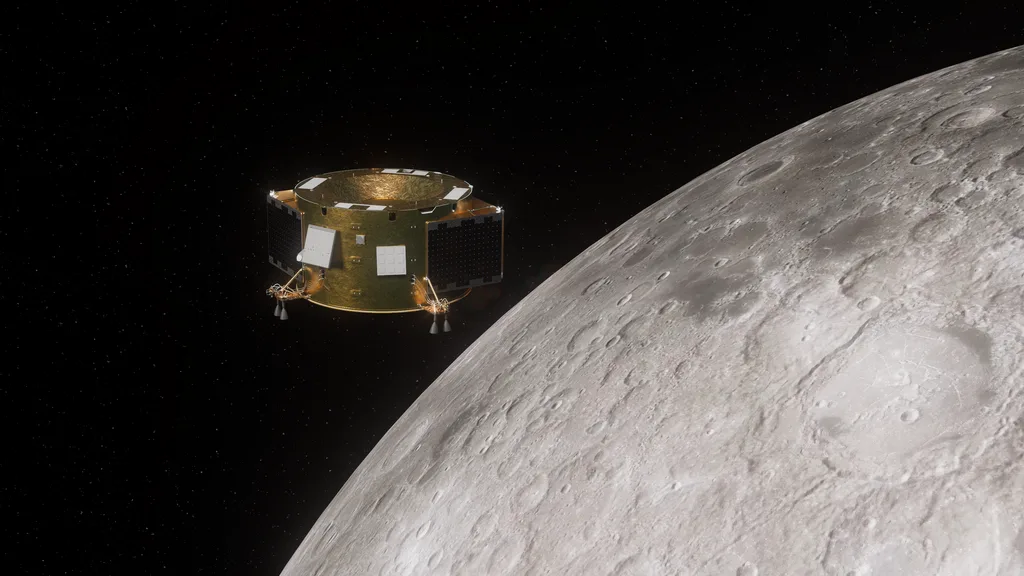
On November 17, Firefly Aerospace announced an agreement to fly the COLLINS navigation payload from Italy's QASCOM on its Elytra Dark orbiter during the third Blue Ghost lunar mission, scheduled no earlier than 2028. Developed on behalf of the Italian Space Agency, COLLINS will explore navigation in lunar orbit using GNSS signals together with future LunaNet-compatible positioning services, including Europe's planned Moonlight infrastructure. Firefly plans roughly six months of COLLINS operations in lunar orbit, with an option to extend the demonstration. The project builds on LuGRE, which demonstrated reception of terrestrial GNSS signals on the Moon during the first Blue Ghost mission.
Why it matters: Satellite navigation designed around Earth is becoming a starting point for navigation around the Moon. Testing how Earth-based GNSS and future lunar navigation infrastructure work together could help spacecraft navigate autonomously and support more precise landings, but these are future demonstrations, not an operational lunar positioning service.
Source: Firefly Aerospace, November 17, 2026
2. A European RTK coverage map reveals large geographic gaps
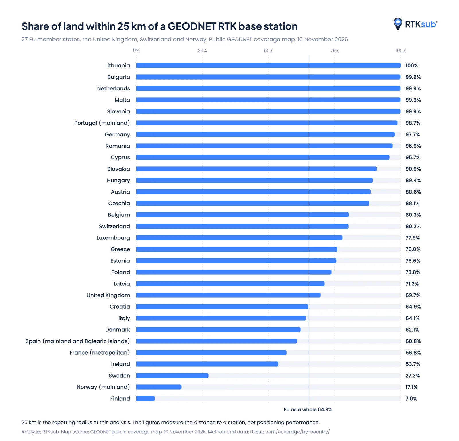
A November 17 report based on Dutch provider RTKsub's analysis of the GEODNET network found that 64.9% of EU land lies within 25 km of one of its GNSS reference stations. The figure is 60.8% for mainland Spain and the Balearic Islands, while regional results range from 22.5% in La Rioja to 98.8% in the Balearics; Galicia stands at 73.0%. Lithuania reaches 100%, while Finland's figure is only 7.0%, reflecting very uneven geographic deployment. RTKsub based its calculations on the network's public coverage map from November 10 and plans to refresh them quarterly.
Why it matters: Nearby reference stations help high-precision GNSS users obtain rapid RTK fixes for surveying, agriculture and robotics. The figures measure proximity to one commercial network's stations, not actual centimetre-level accuracy, availability or the coverage of other correction services; they nevertheless expose where additional infrastructure may be most useful.
Sources: GPS World, November 17, 2026 · RTKsub coverage data and methodology, November 10, 2026
3. Britain's PARALLAX simulates jamming and spoofing without transmitting interference
Force Effect has launched PARALLAX, a training system that inserts simulated GNSS threats between a platform's satellite-navigation antenna and receiver rather than broadcasting interference over the air. Developed through a UK Defence Science and Technology Laboratory-funded programme and commercialised under licence from Ploughshare, it lets exercise controllers model virtual jammers, spoofers and terrain-dependent signal effects as vehicles, vessels or unmanned systems move. Instructors can change scenarios during exercises and review how crews and equipment respond to degraded or deceptive positioning. The product is offered to authorised government, defence and other approved users and is subject to UK military export controls.
Why it matters: Training with real jamming transmitters risks disrupting nearby aviation and other systems. Conducted-signal simulation creates a way to practise navigation failure and deception on real platforms without radiating the simulated interference into the surrounding environment.
Source: GPS World, November 17, 2026
4. A European GNSS chip combines 1 mW operation with Galileo authentication

At electronica 2026 in Munich, held November 10-13, Dutch chipmaker Qualinx demonstrated its QLX3Gx reconfigurable GNSS receiver. A follow-up technical report described a 1 mW consumption figure in its 1 Hz cyclic operating mode, a compact 5 × 5 mm package, support for multiple GNSS constellations and bands, and Galileo OSNMA navigation-message authentication integrated on the chip. Qualinx says its Digital RF architecture allows software configuration of reception and power use, with evaluation hardware aimed at developers of trackers, wearables and industrial IoT devices. The energy figure is vendor-reported and does not describe every mode of operation.
Why it matters: Low power and authenticated satellite navigation are particularly valuable in battery-operated devices that may remain in the field for years. Putting OSNMA in the receiver silicon could help small devices reject forged navigation messages, although authentication alone cannot eliminate jamming or guarantee a correct position.
Sources: everything RF, November 2026 · Qualinx, electronica 2026 announcement
5. Wear OS watches can borrow a phone's GNSS during outdoor workouts
Google's official release notes for Play services v26.45, dated November 16, describe a new option for smartwatches to track outdoor workouts using the paired phone's GNSS receiver. This can reduce power consumption on the watch when the user carries the phone and the phone is not in Battery Saver mode. The feature was reported more widely on November 17, but Google has not provided a complete compatibility list or quantified the expected battery savings.
Why it matters: The change shifts continuous satellite reception from a small watch battery to a much larger phone battery, potentially extending recording time on long runs, hikes or rides. It illustrates how software coordination between devices can improve real-world navigation endurance without requiring new satellites or receiver chips.
Sources: Google System Services release notes, November 16, 2026 · Android Authority, November 17, 2026
Outlook
The direction is clear: positioning is becoming more adaptable. New lunar experiments extend navigation beyond Earth, reference networks improve local precision, controlled testing prepares users for hostile signal conditions, and efficient hardware and software make GNSS more practical in small devices.
Related articles
GNSS Daily Briefing - November 20, 2026
Galileo GSAT0209 outage, Russian autonomous-truck safety controls, Spain's HES01, UK resilient PNT requirements and civilian risks from GNSS jamming tests.
GNSS Daily Briefing - November 19, 2026
Eutelsat's alternative-PNT contract, maritime BeiDou standards, Russia's GEOKOSMOS, India's NavIC NVS-03 and Hera's asteroid navigation.
GNSS Daily Briefing - November 13, 2026
Resilient PNT requirements, Spain's HES01, acoustic positioning offshore, GPS test safety and a new multi-GNSS IoT module.
GNSS Daily Briefing - November 14, 2026
Japan sets a timetable for Michibiki-7, Finland counts rising GPS interference, BeiDou-linked positioning moves underground, Spain advances Galileo G2 ground infrastructure, and Xona expands LEO navigation.
Comments
Sign in to comment.
No comments yet.