GNSS Daily Briefing - 12 November 2026
Galileo drone tests in Galicia, a likely GLONASS launch, Korea's independent timing network, anti-jam antennas and resilient construction positioning.

The latest developments in satellite navigation show how positioning and timing are moving beyond simple reliance on a clear GNSS signal. European drone trials are putting Galileo services to the test in challenging terrain, while South Korea is building a terrestrial route for distributing national time.
A fresh Russian orbital launch, new adaptive antenna building blocks and more resilient construction-machine positioning illustrate the same shift: critical users increasingly need to verify their navigation data, withstand interference and retain alternatives when satellite signals deteriorate.
1. Galileo and EGNOS take to the skies over Galicia
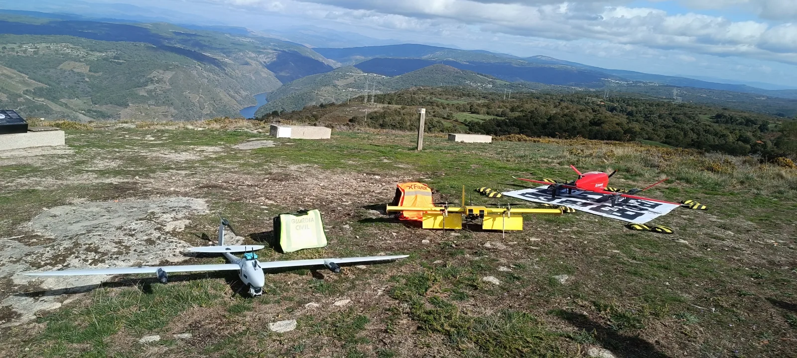
Photo: ESSP / EGNOS User Support.
On 11 November, Europe's EGNOS service provider ESSP reported on drone flight tests carried out on 20-21 October in Ribeira Sacra, northwestern Spain, under a campaign coordinated by EUROCONTROL, EUSPA and EASA. Specially developed onboard receiver boxes recorded performance data for GPS, Galileo Open Service, Galileo's OSNMA authentication, High Accuracy Service (HAS) and EGNOS under real flight conditions. Flights near the Triguás viewpoint and Cadaval airfield covered contrasting terrain, with an emphasis on beyond-visual-line-of-sight operations and electronic conspicuity; the detailed GNSS measurements are still being analysed.
Why it matters. Reliable satellite navigation, including integrity and authentication, is a prerequisite for safely scaling drone inspection, emergency-response and logistics services beyond controlled demonstrations. Field data in difficult terrain can help regulators and operators distinguish useful capabilities from assumptions based on ideal sky visibility.
Source: EGNOS User Support - ESSP supporting EUROCONTROL UAS flight tests in Galicia (11 November)
2. Russia's new orbital launch points to GLONASS replenishment
Russia launched a Soyuz-2.1b/Fregat from Plesetsk on 7 November, placing a spacecraft into its planned orbit according to official military reporting. Subsequent orbital tracking recorded an object at roughly 19,200 km altitude, in the orbital regime used by GLONASS, and spaceflight analyst Anatoly Zak identified it provisionally as a GLONASS-K1 spacecraft, possibly Kosmos-2621. The exact payload designation has not been publicly confirmed, so the satellite's identity should be treated as provisional rather than an official announcement of operational service.
Why it matters. Replenishing medium-Earth-orbit navigation satellites is essential for maintaining constellation geometry and continuity as older spacecraft age. Launch success alone does not establish that a new satellite has completed checks or joined the operational GLONASS signal service.
Source: RussianSpaceWeb - Soyuz launch from Plesetsk, updated 9 November
3. South Korea advances a precision-time network without GNSS
On 10 November, GPS World reported that Korea's standards institute KRISS and research-network operator KISTI are developing Time-Net Korea, a network that will distribute national standard time over existing optical communications infrastructure. The partners have also examined geostationary satellites and terrestrial broadcasting as complementary delivery paths. In a recent experiment, precision timing was transmitted over a 230-kilometre link between KRISS and the Yonsei Radio Observatory, with picosecond-level precision reported.
Why it matters. Telecommunications, power grids and data centres need trustworthy time even when GPS or other GNSS timing receivers are jammed or spoofed. A fibre-based national timing backbone provides a physically different distribution channel, reducing the risk of a single radio-frequency failure affecting many services at once.
Source: GPS World - Korea to build precision time and frequency network (10 November)
4. Taoglas offers a practical starting point for anti-jam GNSS antennas

Image: Taoglas, via Inside GNSS.
Taoglas unveiled a controlled reception pattern antenna (CRPA) reference design on 10 November and is demonstrating it at the electronica exhibition in Munich. The design combines commercial multi-band antenna elements, TFM.110A front ends and supporting circuitry for GPS, Galileo, GLONASS and BeiDou; a four-element configuration can theoretically place up to three reception nulls toward interference sources. It is a reference platform, not a finished anti-jamming receiver: beamforming algorithms, calibration and the GNSS processing chain remain the integrator's responsibility.
Why it matters. Interference suppression increasingly depends on antenna geometry and spatial processing rather than frequency filtering alone. A documented, component-based reference architecture could shorten prototyping cycles, but real-world performance still has to be validated in the completed system.
Source: Inside GNSS - Taoglas releases CRPA reference design (11 November)
5. Trimble brings new GNSS resilience to earthmoving equipment

Photo: Trimble.
At its Dimensions 2026 conference on 9-11 November, Trimble introduced MP1087, a compact positioning and communications unit for Earthworks machine-control systems. It combines previously separate hardware functions and integrates Wi-Fi, cellular, UHF and network connectivity. The unit also uses Trimble's next-generation Maxwell 8 GNSS technology, which the company says offers improved performance and new anti-jamming and anti-spoofing capabilities; independently measured field results were not provided in the announcement.
Why it matters. Automated grading and excavation depend on consistent high-precision positioning and timely equipment data exchange. Consolidating the positioning hardware while strengthening resistance to signal manipulation may help construction sites reduce downtime, though performance claims must be tested in actual conditions.
Source: Trimble - MP1087 launch announcement (9 November)
Outlook
The common direction is clear: satellite signals remain indispensable, but resilient PNT now combines authenticated measurements, adaptive antennas, independent timing paths and application-specific verification. The biggest gains will come from testing these approaches in the conditions where navigation is hardest, not only where reception is perfect.
Related articles
GNSS Daily Briefing - November 20, 2026
Galileo GSAT0209 outage, Russian autonomous-truck safety controls, Spain's HES01, UK resilient PNT requirements and civilian risks from GNSS jamming tests.
GNSS Daily Briefing - November 13, 2026
Resilient PNT requirements, Spain's HES01, acoustic positioning offshore, GPS test safety and a new multi-GNSS IoT module.

GNSS Daily Briefing - November 15, 2026
China launches a professional GNSS surveying range, handheld GNSS imaging advances, u-blox miniaturises receivers, Spain invests in resilient PNT and Galileo reports Q3 performance.

GNSS Daily Briefing - November 17, 2026
BeiDou adoption approaches 42 million professional devices; Europe's flying 5G positioning; Dutch GPS interference; Russia's ERA-GLONASS emergency-response figures; offshore GNSS-independent navigation.
Comments
Sign in to comment.
No comments yet.