GNSS Daily Briefing - November 17, 2026
BeiDou adoption approaches 42 million professional devices; Europe's flying 5G positioning; Dutch GPS interference; Russia's ERA-GLONASS emergency-response figures; offshore GNSS-independent navigation.

Satellite navigation is increasingly judged by what happens when the signal is weak, unavailable or simply not trustworthy. This week's developments range from hard evidence of BeiDou's expanding reach to a flying 5G positioning experiment, a short-lived GPS disruption affecting European aircraft and a subsea navigation system that keeps industrial work moving without a dependable satellite fix.
At the same time, Russia's ERA-GLONASS network shows the practical value of reliably transmitting location data when seconds matter. Together, the stories point to a navigation ecosystem that is becoming both more widely used and more dependent on independent backups.
1. China: Nearly 42 million professional BeiDou terminals in use
China's GNSS & LBS Association released its 2026 BeiDou industry development index report in Beijing on November 17. By mid-2026, the country had almost 42 million BeiDou-enabled terminals outside consumer electronics, an increase of nearly nine million, or approximately 27%, in a year; the report puts comprehensive industry adoption above 90%. In consumer markets, more than 98% of the 124 million smartphones shipped domestically in the first half of the year supported BeiDou, while the report counted around ten million BeiDou-equipped passenger vehicles shipped and 26 million BeiDou-enabled electric bicycles sold.
Why it matters: These figures put a measurable scale on BeiDou's transition from a national space programme into transport, industrial operations and everyday devices. They describe the Chinese association's reported adoption metrics, not an independent assessment of positioning accuracy or a count of active satellite receivers.
Source: Xinhua, November 17, 2026
2. Europe: An airborne 5G network demonstrates sub-metre positioning

A European Space Agency NAVISP project led by Airbus has tested a hybrid navigation system using terrestrial 5G stations and radio units carried by drones, according to results reported on November 16. The HOP-5G consortium used 5G positioning reference signals and GNSS together: earlier field results put two-dimensional error below one metre for more than 90% of the dataset, while a separate real-time 5G ranging demonstration reached sub-metre performance at the 95% level. The team also investigated millimetre-wave angle-of-arrival measurements and found, in simulation, that combining degraded GNSS with 5G reduced error from about six metres with 5G alone to below one metre.
Why it matters: Movable 5G transmitters could provide additional geometry and local coverage when ordinary satellite navigation struggles, particularly for vehicles, drones and temporary worksites. The demonstrated results are promising, but they do not yet amount to a widely deployed alternative to GNSS.
Source: Inside GNSS, November 16, 2026
3. Netherlands: GPS disruption affects dozens of aircraft
A GPS interference event on November 9 affected aircraft over the Netherlands and the North Sea, with new details reported on November 16. Analysis of aircraft tracking data suggests roughly 80 aircraft encountered degraded GPS accuracy within approximately 20 minutes; seven reported Required Navigation Performance problems while approaching Amsterdam Schiphol. Dutch air traffic control considered deliberate jamming a plausible explanation, but a transmitter and its operator have not been conclusively identified; the affected flights landed safely with controller assistance.
Why it matters: GNSS interference is not confined to the familiar Baltic and eastern Mediterranean hotspots. Even a brief episode near a major Western European airport can disrupt precision approaches, reinforcing the operational importance of ground-based aids, crew procedures and independent monitoring.
Source: GPS World, November 16, 2026
4. Russia: ERA-GLONASS passes 100,000 emergency alerts in 2026
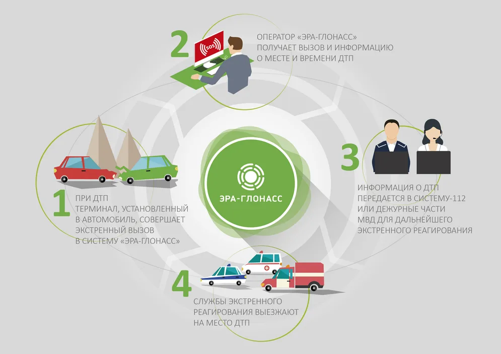
Russia's Transport Ministry reported on November 16 that its ERA-GLONASS vehicle emergency-response network had forwarded more than 100,000 alerts to rescue services since the start of the year, 12% more than in the comparable period of 2025. Around 85% of the alerts were triggered automatically in serious road crashes, and the ministry says location and vehicle information reach regional emergency dispatch systems digitally in an average of 19 seconds. The service has accumulated about 650,000 alerts since launch and now covers more than 14.4 million connected vehicles.
Why it matters: Accurate location is especially valuable when crash victims cannot speak or do not know where they are. The figures illustrate how positioning and telematics can shorten the information handoff in emergency response, although they do not by themselves measure reductions in ambulance arrival times or fatalities.
Source: Russian Ministry of Transport, November 16, 2026
5. Middle East: Pipelay vessels navigate without reliable GNSS

Offshore survey company UTEC is using a hybrid acoustic-inertial positioning solution for two subsea pipeline installation projects in the Middle East spanning more than 150 km, Inside GNSS reported on November 12. Developed with Sonardyne, the system combines seabed acoustic transponders, inertial navigation and Doppler velocity measurements, treating GNSS as an extra reference when the signals are trustworthy. Its configuration supports pipe-laying barges and anchor-handling tugs operating in water less than 50 metres deep, allowing work to proceed in conditions where satellite-navigation disruptions might otherwise halt operations.
Why it matters: This is an industrial deployment of alternative PNT, rather than a laboratory proposal. Independent acoustic references and inertial sensors can maintain a usable position solution in an interference-prone marine environment, reducing dependence on one vulnerable radio system.
Source: Inside GNSS, November 12, 2026
Outlook
The most meaningful shift is not away from GPS, GLONASS, Galileo or BeiDou, but toward navigation systems that can verify, supplement and survive their signals. The growth of BeiDou-equipped devices shows how deeply GNSS is embedded in daily life; Europe's experimental 5G positioning and offshore acoustic-inertial operations show what the next layer of resilience may look like.
Related articles
GNSS Daily Briefing - November 19, 2026
Eutelsat's alternative-PNT contract, maritime BeiDou standards, Russia's GEOKOSMOS, India's NavIC NVS-03 and Hera's asteroid navigation.
GNSS Daily Briefing - November 15, 2026
China launches a professional GNSS surveying range, handheld GNSS imaging advances, u-blox miniaturises receivers, Spain invests in resilient PNT and Galileo reports Q3 performance.

GNSS Daily Briefing - October 25, 2026
Satellite sensing of GNSS jamming, NATO test equipment, Iridium-backed positioning, real-time precision limits and C-band antennas.
GNSS Daily Briefing - October 23, 2026
NavIC NVS-03, Sweden's anti-jamming GPS order, near-instant centimetre precision and resilient aviation navigation.

Comments
Sign in to comment.
No comments yet.