GNSS Daily Briefing - November 14, 2026
Japan sets a timetable for Michibiki-7, Finland counts rising GPS interference, BeiDou-linked positioning moves underground, Spain advances Galileo G2 ground infrastructure, and Xona expands LEO navigation.

Satellite navigation is entering a more demanding phase: users want trustworthy position and time even when familiar GNSS signals are disrupted, while service providers are preparing new capabilities both above and below ground. Recent developments in Japan, northern Europe, China, Spain and low Earth orbit show how much of that work has moved from concept to engineering and field operations.
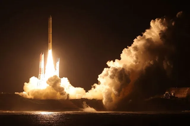
1. Japan sets a service timetable for Michibiki-7
Japan's Cabinet Office announced on November 13 that its QZSS satellite Michibiki-7, launched on August 11, remains in commissioning and parameter-tuning tests. Its positioning, MADOCA-PPP high-accuracy corrections, QZNMA signal authentication and positioning-technology demonstration services are expected to begin in late February 2027, with satellite-based augmentation (SBAS) planned around May. SBAS test messages have been transmitted since November 8, but the authorities have not yet confirmed final operational dates.
Why it matters: Michibiki-7 is more than an additional navigation signal over the Asia-Pacific region. Its planned services combine precision corrections and authentication, including authentication data relating to GPS and Galileo signals, in a platform that could give compatible receivers a more reliable positioning solution.
Source: Japan Cabinet Office / QZSS, November 13, 2026
2. Finland records more than 2,400 aviation GPS interference reports in 2026
In a statistical overview updated November 12, Finnish transport and communications regulator Traficom reported 2,451 aviation GPS interference reports through the end of October 2026, compared with 1,704 in all of 2025. The agency also counted 406 vessels affected by reported GNSS disturbances in Finnish waters over the first ten months of 2026, following 231 maritime reports in 2025; it cautions that the maritime counting method changed in January, limiting direct year-on-year comparison. Traficom says interference has been a daily issue for aviation in southern Finland since January 2024, while ships in the Gulf of Finland need to be prepared to use alternative navigation methods.
Why it matters: These figures turn the abstract risk of jamming and spoofing into a measurable burden on transport operations. They also reinforce the need to design and regularly practise navigation procedures that do not rely on a functioning GNSS receiver.
Source: Traficom, updated November 12, 2026
3. BeiDou-linked positioning reaches underground parking and mines
China's CETC54 research institute has developed the Xingyuan underground positioning system, according to a November 3 report from Xinhua following a national project acceptance review. The system uses underground micro-base stations and a mapped radio environment to make location guidance possible where satellite signals cannot penetrate; the researchers report static pedestrian positioning better than 0.2 metres and sub-metre accuracy for fast-moving unmanned vehicles in tests. It is being extended from parking facilities into underground coal-mine operations, including personnel and vehicle positioning.
Why it matters: Navigation continuity is often lost at the entrance to a tunnel, car park or mine. Integrating terrestrial positioning with a BeiDou-based location ecosystem points toward seamless navigation across the surface-underground boundary, although the stated performance figures are project-reported rather than independent validation.
Source: Xinhua, November 3, 2026
4. Spain's Indra to build the next generation of Galileo ground stations
The European Space Agency reported on October 28 that Indra Space had signed two contracts to develop new ground infrastructure for Galileo's second generation. The programme covers stations that monitor satellite signals and facilities that upload navigation data, supporting both existing and future Galileo spacecraft. New receiving technologies, including interference-resistant antenna concepts and more flexible software-defined systems, are intended to improve the reliability and security of Galileo's ground segment; deployment will follow development and qualification.
Why it matters: A stronger satellite constellation depends on equally robust monitoring and uplink stations. The contracts give Spanish industry a central role in Galileo's evolution while addressing a critical, often overlooked part of satellite-navigation resilience.
Source: European Space Agency, October 28, 2026
5. Six Xona satellites mark a commercial step toward low-orbit navigation
Six Xona Pulsar spacecraft reached low Earth orbit on a Falcon 9 rideshare mission in late October, according to an October 28 report by Inside GNSS. Four are designed to support early service demonstrations, while two test a production-oriented satellite design as the company builds toward a much larger constellation. Xona targets initial commercial access in 2027, initially with intermittent passes rather than continuous global coverage.
Why it matters: Low-orbit navigation promises stronger received signals and an additional source of positioning and time alongside traditional medium-orbit GNSS. The launch marks tangible progress toward that architecture, but full-time global service will require many more satellites and operational validation.
Source: Inside GNSS, October 28, 2026
Outlook
The next phase of positioning, navigation and timing is unlikely to be defined by a single replacement for GPS, GLONASS, Galileo or BeiDou. It is being assembled from authenticated broadcasts, stronger ground infrastructure, independent radio references and complementary satellite orbits - with practical performance measured under the conditions that make navigation difficult.
Related articles
GNSS Daily Briefing - November 20, 2026
Galileo GSAT0209 outage, Russian autonomous-truck safety controls, Spain's HES01, UK resilient PNT requirements and civilian risks from GNSS jamming tests.
GNSS Daily Briefing - November 17, 2026
BeiDou adoption approaches 42 million professional devices; Europe's flying 5G positioning; Dutch GPS interference; Russia's ERA-GLONASS emergency-response figures; offshore GNSS-independent navigation.

GNSS Daily Briefing - October 25, 2026
Satellite sensing of GNSS jamming, NATO test equipment, Iridium-backed positioning, real-time precision limits and C-band antennas.
GNSS Daily Briefing - October 23, 2026
NavIC NVS-03, Sweden's anti-jamming GPS order, near-instant centimetre precision and resilient aviation navigation.
Comments
Sign in to comment.
No comments yet.