GNSS Daily Briefing - November 22, 2026
Arkhangelsk's ground-beacon bus tracking, aircraft GNSS integrity reports, Galicia drone tests, the US GPS SPIDER plan and magnetic-navigation integrity.

Reliable positioning is increasingly built around a simple question: what happens when satellite navigation becomes incomplete, misleading or unavailable? Recent developments range from a beacon-backed bus-tracking pilot in northern Russia and large-scale aircraft navigation-quality observations to European drone trials, a GPS ground-control modernization plan and a new approach to checking the integrity of magnetic navigation.
Together, they show that trusted position and time depend as much on monitoring, ground infrastructure and independent reference data as on the satellites themselves.
1. Arkhangelsk buses gain a ground-beacon backup to GPS and GLONASS
A report published on November 21 describes a pilot alternative-positioning system developed by the Arkhangelsk Communications Center with Russian telematics manufacturer Galileosky. After a month of trials, the regional authorities decided to equip buses in Arkhangelsk, Novodvinsk and Severodvinsk with Galileosky 10 terminals supported by fixed ground beacons. The aim is to keep vehicle location reports useful to dispatchers when GPS or GLONASS reception is weak; wider deployment and independently measured accuracy are not yet established.
Why it matters: A transport dispatcher needs a trustworthy account of where a bus actually is, not simply the most recent coordinates from a satellite receiver. Ground references can make city fleet monitoring more resilient, but the cost of maintaining beacons and connecting the resulting data to existing platforms will determine whether the model scales.
Source: IT Russia, November 21, 2026
2. Aircraft data show widespread degraded GPS-position reports around European Russia
In a November 21 update covering flights on November 20, independent monitor GPSInterference.com reported that 438 of 506 aircraft observed near the main airports in European Russia, or 86.6%, transmitted reduced positioning-accuracy indicators at least once. Its regional map flagged degraded reports in 90.6% of monitored grid areas, including 89.8% in the highest-severity category. The figures come from aircraft-broadcast ADS-B navigation accuracy (NACp), not direct measurements of radio interference: equipment problems or other causes can produce similar indicators, and the data cannot identify any transmitter or responsible party.
Why it matters: Aircraft-reported position quality provides a practical, independently observable warning that navigation conditions may be unreliable, even when operators do not publish detailed incident reports. The sharp-looking percentages must be read as proportions of the sample and monitored areas, not as proof that all flights lost GPS or that a particular jamming source has been located.
Source: GPSInterference.com, European Russia report updated November 21, 2026 · Measurement methodology and limitations
3. Galileo, EGNOS and authentication services go flying with drones in Galicia
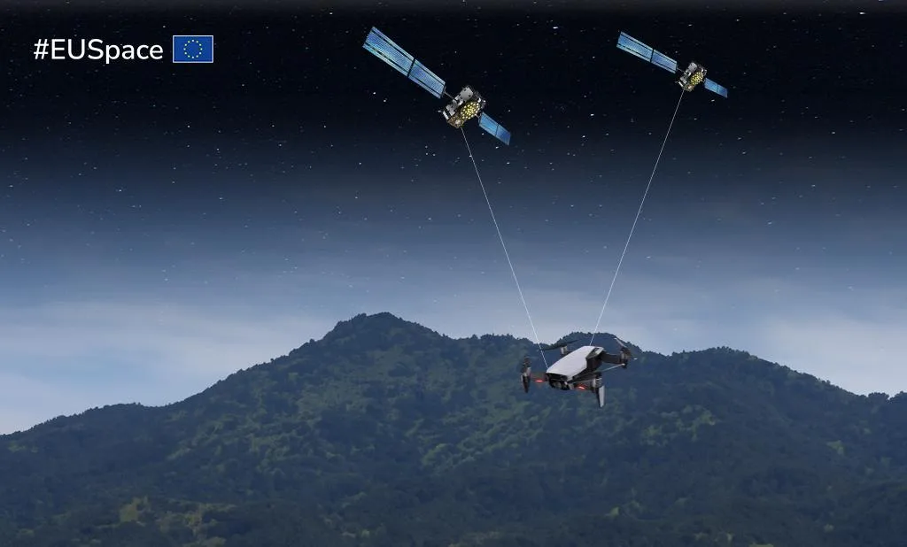
On November 18, EUSPA detailed a joint European drone flight campaign held on October 20-21 at the ESCAI test area in Ribeira Sacra, Galicia, Spain. EUROCONTROL, EUSPA, EASA and partners installed purpose-built GNSS data-collection equipment on participating aircraft to compare Galileo Open Service, High Accuracy Service (HAS), Open Service Navigation Message Authentication (OSNMA) and EGNOS under realistic flying conditions. The flights included challenging terrain and scenarios relevant to beyond-visual-line-of-sight operations; the resulting measurements will be analysed for accuracy, availability, signal quality and reliability rather than treated as already-validated performance claims.
Why it matters: Future delivery, inspection and emergency-service drones need positioning they can trust in complex airspace and terrain. Field evidence gathered with different receivers can help regulators and developers evaluate which European GNSS capabilities actually support safe autonomous operations.
Source: EUSPA, November 18, 2026 · ESSP technical account, November 11, 2026
4. US Space Force plans a continuous-upgrade model for GPS ground control

The US Space Systems Command published a November 20 request for information for SPIDER, a prospective long-term successor to the GPS Control Segment Sustainment II contract. Rather than keeping legacy ground-control hardware and software running as a largely separate activity, the proposed scope combines sustainment with the ongoing integration of modernization changes for newer GPS satellites and military capabilities. It is a market-research notice, not an awarded contract; industry responses are due in early January 2027.
Why it matters: A satellite constellation is only as adaptable as the control systems responsible for operating and updating it. Modernizing the ground segment while preserving dependable day-to-day GPS service is a major systems-engineering challenge with consequences beyond the space vehicles themselves.
Source: US Space Systems Command SPIDER notice, November 20, 2026, via GovChime · Notice and requirements summary
5. AMISS proposes integrity checks for GPS-independent magnetic navigation
In a research preprint submitted on November 18, Sharad C. Shankar and colleagues introduced AMISS, a framework for checking the integrity of magnetic-anomaly navigation. Such navigation compares onboard magnetic-field measurements with maps of the Earth's crust, offering an alternative when GNSS is jammed or spoofed, but errors in the maps can also mislead the estimated position. The researchers adapted the solution-separation concept familiar from GNSS integrity monitoring to compare measurements over time, detect corrupted map data and estimate protective bounds on position error; the reported evaluation uses synthetic aircraft trajectories with injected faults.
Why it matters: An alternative to GPS is not automatically a trustworthy navigation solution. Estimating when a magnetic map cannot safely support a position fix is a necessary step toward using this technology in safety-critical aircraft and autonomous systems, although real-flight validation remains to be demonstrated.
Source: Shankar et al., "AMISS: An Integrity Framework for Magnetic Navigation", arXiv, November 18, 2026
Outlook
The shared direction is toward navigation that can explain its own reliability. Whether the reference comes from a satellite, a roadside beacon, an aircraft receiver or a magnetic map, the next essential capability is to detect bad information early and switch to something that can be independently checked.
Related articles
GNSS Daily Briefing - November 18, 2026
Lunar GNSS/LunaNet experiment, Europe's GEODNET RTK gaps, non-radiating spoofing simulation, a 1 mW Galileo-authenticated chip, and phone-assisted Wear OS GNSS.
GNSS Daily Briefing - November 20, 2026
Galileo GSAT0209 outage, Russian autonomous-truck safety controls, Spain's HES01, UK resilient PNT requirements and civilian risks from GNSS jamming tests.
GNSS Daily Briefing - October 28, 2026
Galileo G2 expands; UTC reform, Russian drone identification, Galileo HAS structural sensing and Canary Islands GPS anomalies.
GNSS Daily Briefing - October 23, 2026
NavIC NVS-03, Sweden's anti-jamming GPS order, near-instant centimetre precision and resilient aviation navigation.

Comments
Sign in to comment.
No comments yet.